Feb
24.
________________
Only one more day left to win this week. Here again is my weekly weather quiz question. What is a fire tornado? Please post your answer as a comment by clicking on “no comments” in the upper right hand portion of this page under the caption, then add your comment. The first person to post the correct answer will win a week of free personalized weather forecasts tailored to your needs. The answer has to be a comment to win. An email answer will not count. Good luck.
________________
The jet stream shows a cold trough of low pressure ( “U” shaped area) starting to swing down and it is already bringing winter weather ahead of and then with it. A burst of cold Arctic air is pushing in behind another cold front sliding down from the North. Be careful driving on snow covered or icy roads. The colder temperatures will turn snow left on the streets into icy spots. Remember to do everything in slow motion. No quick moves while driving under these conditions.
________________
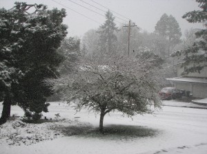
I live at 600 ft. on the South side of Eugene. Here’s a look at the height of the snow storm in my neighborhood.
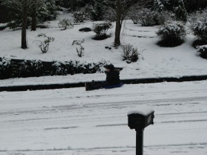
One of my neighbor’s children enjoyed sledding.
________________
Advisories: A WINTER WEATHER ADVISORY IS IN EFFECT UNTIL 10 PM TONIGHT FOR THE NORTH AND CENTRAL OREGON COAST AND COAST RANGE, THE NORTH OREGON CASCADE FOOTHILLS AND THE FOOTHILLS OF LANE COUNTY, THE NORTH OREGON CASCADES AND THE CASCADES OF LANE COUNTY, THE LOWER COLUMBIA-I-5 CORRIDOR, THE GREATER PORTLAND AND VANCOUVER AREAS, AND THE WESTERN COLUMBIA RIVER GORGE, THE CENTRAL AND SOUTH WILLAMETTE VALLEY AND THE UPPER HOOD RIVER VALLEY. A WINTER WEATHER ADVISORY IS IN EFFECT UNTIL 10PM TONIGHT FOR THE SOUTH CENTRAL AND SOUTH OREGON COAST, COUNTY CENTRAL DOUGLAS COUNTY, THE EASTERN DOUGLAS COUNTY FOOTHILLS, EASTERN CURRY, AND JOSEPHINE, AND JACKSON COUNTY. A FREEZE WARNING IS IN EFFECT FROM 10 PM TONIGHT THROUGH 10 AM FRIDAY FOR THE SOUTH CENTRAL, AND THE SOUTH OREGON COAST. A FREEZE WATCH IS IN EFFECT FROM LATE FRIDAY NIGHT THROUGH SATURDAY MORNING FOR THE SOUTH CENTRAL AND SOUTH OREGON COAST, CENTRAL DOUGLAS COUNTY, EASTERN CURRY COUNTY, JOSEPHINE COUNTY, AND JACKSON COUNTY.
_________________
Here are your detailed forecasts. **
_________________
Forecast for the Southern and lower Mid Willamette Valley including Eugene-Springfield and Albany-Corvallis: Mostly cloudy and cold with evening snow showers likely (60%), a (40%) of snow showers late tonight (1 in. of snow possible) (record low likely), mostly cloudy Friday AM, partly cloudy Friday afternoon, mostly clear and very cold Friday night (record low likely), just partly cloudy Saturday, mostly cloudy with a (30%) chance of rain and snow Saturday evening, a (30%) chance of snow Saturday night, snow and rain likely (60%) Sunday AM, rain likely in the afternoon and Sunday night lows 20-12 warming to 27 Saturday night and 34 Sunday night highs 34-46. Mostly cloudy with rain likely (60%) Monday, a good (50%) chance of rain Monday night, then rain likely (60%) Tuesday through Thursday highs 47-54 lows 35-39. (seasonal averages high 53 low 36)
_______________
Forecast for the Umpqua Basin including, Roseburg: Mostly cloudy with snow showers likely (60%) tonight (1 in. of snow possible), mostly cloudy with a slight (20%) chance of snow showers Friday AM, mostly cloudy Friday afternoon and evening, clearing Friday night, just partly cloudy Saturday, mostly cloudy with a slight (20%) chance of rain and snow Saturday night, cloudy with a (40%) chance of rain and snow Sunday, then rain and snow likely (60%) Sunday night lows 24-20 warming to 26 Sunday highs 40-45. Cloudy with a (40%) chance of rain and snow showers Monday and Monday night, showers likely (60%) Tuesday, then rain likely (60%) Tuesday night through Thursday highs 50-54 lows 35-38. (seasonal averages high 57 low 37)
_______________
Forecast for the South Oregon Coast including Coos Bay and North Bend: Mostly cloudy with , coastal rain and snow showers this evening, evening rain and snow showers likely (60%) inland this evening, a good (50%) chance of snow showers late tonight (1 in. of snow possible), a slight (20%) chance of AM rain and snow showers Friday, mostly cloudy in the evening, partly cloudy Friday night and Saturday, mostly cloudy with a (30%) chance of coastal rain and a slight (20%) chance of rain and snow inland Saturday night, mostly cloudy with rain likely (60%) Sunday and Sunday night lows 26-40 highs 42-50. Mostly cloudy with showers likely (60%) and breezy Monday and Monday night, showers likely (60%) Tuesday, rain likely (60%) and breezy Tuesday night and Wednesday, then rain likely (60%) Wednesday night and Thursday highs 46-54 lows near 40. (seasonal averages high 55 low 41).
_________________
Forecast for the Cascades of Lane County: Mostly cloudy with snow showers and very cold tonight, snow showers likely (60%) this evening, a good (50%) chance of snow showers late (1-3 in. of snow possible), partly cloudy with a slight (20%) chance of snow showers Friday, partly cloudy and very cold Friday night, mostly sunny Saturday AM, partly cloudy in the afternoon, partly cloudy with a slight (20%) chance of snow in the evening, mostly cloudy with a (40%) chance of snow and not as cold Saturday night, then snow likely (60%) Sunday and Sunday night snow level at the surface tonight and Friday, free air freezing level at the surface Friday night and Saturday, snow level at the surface Saturday night through Sunday night lows 7-23 highs 20-32. Mostly cloudy with snow likely (60%) Monday and Monday night, snow and rain likely (60%) Tuesday and Tuesday night, rain likely (60%) Wednesday, then rain and snow likely (60%) Wednesday night and Thursday snow level at the surface Monday, 2,500 ft. Monday night, rising to 3,000 ft. Tuesday, 4,000 ft. Tuesday night, 5,500 ft. Wednesday, falling to 4,500 ft. Wednesday night, and 3,500 ft. Thursday highs 32-43 lows 23-30.
_________________
**Because weather forecasting is a combination of science, intuition, and timing there can be no absolute guarantees that individual forecasts will be 100% accurate. Nature is in a constant state of flux and sudden unexpected weather events can happen.


